***PLEASE*** support this page and help me continue to keep you safe and aware…
You can subscribe or donate at
https://madcoweather.com/support-madcowx/
or PATREON at https://www.patreon.com/madcowx
or PayPal to andersoninwx@gmail.com
or Zelle to andersoninwx@gmail.com
or Cash App to $madcowx
or Venmo to @MadCoWx
You can also help the page earn from Facebook by Watching the Videos, Clicking on the Forecasts, Reacting to posts, and Commenting on posts, even with emojis.
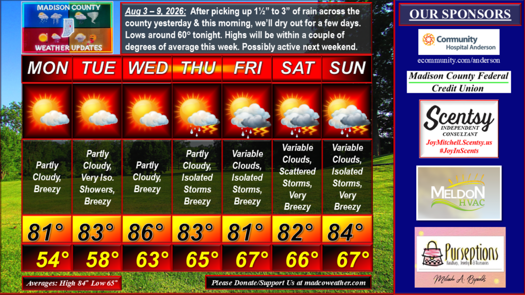
After picking up 1½” to 3” of rain across the county yesterday & this morning, we’ll dry out for a few days. Lows around 60° tonight. Highs will be within a couple of degrees of average this week. Possibly active again next weekend. #MadCoWx #INwx
THANK YOU to those of you who are page Patrons, Subscribers, and Donors and to the page’s Sponsors:
Meldon HVAC ( https://www.meldonhvac.com )
Weightman Realty Group ( weightmanrealty@aol.com )
Community Hospital Anderson ( ecommunity.com/anderson )
Elwood Fire Equipment ( https://elwoodfireequipment.com/ )
Madison County Federal Credit Union ( https://www.madcofcu.org/ )
Uranus Indiana ( https://www.facebook.com/UranusIndiana )
Joy Mitchell, Independent Scentsy Consultant ( https://joymitchell.scentsy.us/ )
Heavenly Hair Salon ( heavenlyhairsalonanderson.com )
Anderson Symphony Orchestra ( https://andersonsymphony.org/ )
Purseptions Boutique VIP ( https://www.facebook.com/groups/PurseptionsVIP/about/ )
Local Radar
GRLevel3 radar images are not available at this time.